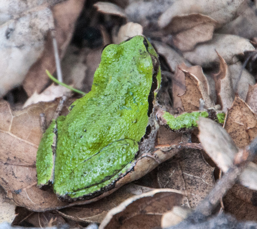
AKA Sierran Tree Frog (Pseudacris sierra). At the sag pond on Coal Mine Ridge, near the Old Spanish Trail. 4/1/2011.br/br/br/br/br/Info from my posting on PVForum, 2/19/2014: Hi All,br/br/br/I recently asked for info about the frog pond near Corte Madera School, and the frogs therein. Thanks to all who replied. And to Dana Breen and Miriam Sachs Martin, who encouraged this endeavor.br/br/br/The froggies are still chorusing, early in the evening, after dark. Soon to quieten… It is probably OK to park on Indian Crossing, just past Corte Madera School, after dark. Or park in an APE (off street parking bay) on Bear Paw, or somewhere near Corte Madera School. Open your car window and bask in the chorus.br/br/br/A summary of the info I found, plus some photos, is now atbr/lt;
http://capturethelight.zenfolio.com/frogpondgt;br/br/br/Here are some of the responses I received to my questions: (Please let me know if you know more!)br/br/br/Paul Heiple:br/The pond is full of Pacific Chor[u]s Frogs, Pseudacris regilla, (or Pseudacris sierra if you are a splitter). These frogs bread in any pools of water, they are doing quite well at the daylighted creek in the town center. Other small pools and ponds are scattered all over the area. I have an artificial pond for them in my yard. Sag ponds are on Coal Mine Ridge and on the trail at the bottom of Windy Hill. Stanford has Lake Lagunita. All of these and even larger permanent lakes are used by these frogs. The vernal pools work best because they have fewer predators. The PC frogs never estivate, they are active all summer but nocturnal. I hear them once in a while giving their dry land call. They are moving to the ponds now, I heard them at our pond last night.br/br/br/I know herons eat frogs, Sibley says kites eat amphibians so frogs might be on the menu. br/br/br/Mary Hufty:br/Frog chorusing is very interesting. A balance between attracting a mate and avoiding a predator. The group protects the individual with the swelling sound which make it is difficult for predators to locate the individual. Most of the frogs are Cal tree frogs, small and very loud.br/br/br/Meredith McClintock:br/The frogs are Pacific Chorus Frogs (aka Pacific Tree Frogs, although I've read they're not actually tree frogs), I'm pretty sure. The frogs are definitely out in the frog pond; I was there this afternoon and there were a lot of frogs singing, although not as many as I've heard in the past, probably due to the prolonged dry spell. With the possible exception of this year, there is water at least in part of the pond for most of the year, as suggested by the cattails.br/br/br/[I disagree. This Frog Pond has no standing water for much of the year. Moisture below ground, quite possibly.]br/br/br/Linda Wagner:br/I'm sure you will get professional answers in great detail, so I will just give you a quick response from what's on the top of my head. The frogs are most likely Pacific Chorus Frogs and they are good at leading a quick life. Earthquake subsidence ponds are not quite the same as vernal ponds also both are caused by a kind of subsidence. Along a fault the rocks are ground into a fine clay. In low places the clay holds the water and swells so that a pond can exist for a while, but in long range time it may be ephemeral. Vernal pools are quite ancient and don't usually form in fault zones (I don't think). They are present around Benicia and into the Delta and also in eastern reaches of the central Great Valley, Modesto maybe? The plants that form perfect rings around the vernal pools are restricted to them and have evolved there over looong time. Some birds hunt the frogs and some birds hunt the birds. How nice for you to be close enough to observe the action! Lindabr/br/br/Bob Dodge:...br/br/Your pond description fits nicely with "SAG" ponds which are not uncommon in areas crisscrossed with faults. They, indeed, are the result of the ground 'sagging' where a fracture occures. There are many in the Bay Area and the biggest example is up near Skyline where the San Andreas crosses Page Mill Road, within the Monte Bello Preserve. This particular Sag Pond is unusual in that there is a spring that flows into it at the southern end so it has water in it year around. The pond marks the juncture of the North American Plate and the Pacific Plate. The NA plate is moving in a generally W direction while the P Plate is moving Northward. This creates the pond where the land has 'sagged' Nearest to you would be Sausal Pond, although dammed would have been a natural depression most likely. I am certain there are others though they may have been filled. There are at least three up on the Earthquake Trail in Los Trancos Preserve.br/br/br/br/br/Targe Lindsay: (Targe, you have to go there just after dark to hear the chorus!)br/Hi Dan,br/br/br/I've been out to the 'frog pond' twice recently... to get the lay of the land. It looks like an area of landslides and alluvium to me as a layman.br/br/br/I've been studying the Geologic Map of the Palo Alto And Part Of The Redwood Point 7-1/2' Quadrangles, San Mateo And Santa Clara Counties, California... and the accompanying booklet. (Miscellaneous Investigation Series published by the U.S. Geological Survey, 1993, Earl H. Pampeyan).br/br/br/I believe the strong'frog pond' area/strong is barely included on the bottom edge of the map.br/br/br/In any case, that general area is in the vicinity of the San Andreas, Pilarcitos, Roble, Jasper, and Hermit Faults... it is a seismicly jumbled up mess.br/br/br/Using the codes on the geologic map, these are the rock types and formations in that general area:br/br/br/strongfg/strong - Greenstone - basaltic volcanic rock with occurances of limestone lenses.br/br/br/strongfl /strong- Limestone - occurs mostly as lenses and beds 8 inches to 2 feet thick in Greenstone.br/br/br/strongQol/strong - Older landslide deposits (Holocene and Pleistocene?), susceptible to reactivation by unusually high or prolonged rainfall, strong earthquake and (or) improper grading or drainage procedures.br/br/br/strongQst/strong - Stream terrace deposits (Holocene? and Pleistocene).br/br/br/strongQTss/strong - Santa Clara Formation (Lower Pleistocene and Upper Pliocene).br/br/br/strongQya/strong - Younger alluvium (Holocene) - locally interfingers with or includes slope wash, ravine fill and colluvium.br/br/br/strongTw/strong - Whiskey Hill Formation - (Upper to Lower Eocene).br/br/br/I don't know if this helps you understand the geology of the area better, or not, but I enjoyed researching it.br/br/br/By the way, I took a 4-year-old boy and his 11-month-old sister to the 'strongfrog pond' /strongthe first day I went out there.... neither saw nor heard a single frog. Only saw a sole male Mallard duck.br/br/br/The 4-year-old exclaimed, "emIt must be duck day!"/embr/br/br/Cheers,br/Targe Lindsay